Filters: Tags: aquifer system (X)
27 results (12ms)|
Filters
Date Range
Extensions Types
Contacts
Categories Tag Types Tag Schemes |

These data were released prior to the October 1, 2016 effective date for the USGS’s policy dictating the review, approval, and release of scientific data as referenced in USGS Survey Manual Chapter 502.8 Fundamental Science Practices: Review and Approval of Scientific Data for Release. This geodatabase contains the spatial datasets that represent the Edwards-Trinity aquifer system in the States of Arkansas, Oklahoma, and Texas. Included are: (1) polygon extents; datasets that represent the aquifer system extent, the entire extent subdivided into subareas or subunits, and any polygon extents of special interest (no data available, areas underlying other aquifers, anomalies, for example), (2) raster datasets for...
This data release contains input data used in model development and TIF raster files used to predict the probability of high arsenic (As) and high manganese (Mn) in groundwater within the glacial aquifer system in the northern United States. Input data include measured As and Mn concentrations at groundwater wells, and associated predictor variable data. The probability of high As and high Mn was predicted using boosted regression tree methods using the gbm package in R version 4.0.0. The response variables for individual models were the occurrence of: (1) As >10 µg/L, and (2) Mn >300 µg/L. Water-quality data were compiled from three sources, as described in Wilson and others (2019): a compilation of data from numerous...
The Mississippi Alluvial Plain (MAP) has become one of the most important agricultural regions in the US, and it relies heavily on a groundwater system that is poorly understood and shows signs of substantial change. The heavy use of the available groundwater resources has resulted in significant groundwater-level declines and reductions in base flow in streams within the MAP. These impacts are limiting well production and threatening future water-availability for the region. This product will help not only scientists in our center, but also at a national level. This product will also be part of a larger study encompassing the Mississippi Alluvial Plain region. The Mississippi Alluvial Plain extent was delineated...

These data were released prior to the October 1, 2016 effective date for the USGS’s policy dictating the review, approval, and release of scientific data as referenced in USGS Survey Manual Chapter 502.8 Fundamental Science Practices: Review and Approval of Scientific Data for Release. The hydrogeology of the valley-fill aquifer system along a 32-mile reach of the Susquehanna River valley and adjacent areas was evaluated in eastern Broome and southeastern Chenango Counties, New York. The surficial geology, inferred ice-marginal positions, and distribution of stratified-drift aquifers were mapped from existing data. Ice-marginal positions, which represent pauses in the retreat of glacial ice from the region, favored...
This data release contains input data used in model development and TIF raster files used to predict the probability of low dissolved oxygen (DO) and high dissolved iron (Fe) in groundwater within the glacial aquifer system in the northern continental United States. Input data include measured DO and Fe concentrations at groundwater wells, and associated predictor variable data. The probability of low DO and high Fe was predicted using boosted regression tree methods using the gbm package in R (v. 4.0.0) in RStudio (v. 1.2.5042). The response variables for individual models were the occurrence of: (1) DO ≤0.5 mg/L, (2) DO ≤2 mg/L, and (3) Fe >100 µg/L. Water-quality data were compiled from three sources, as described...
Categories: Data;
Types: Map Service,
OGC WFS Layer,
OGC WMS Layer,
OGC WMS Service;
Tags: Connecticut,
Geochemistry,
Hydrology,
Idaho,
Illinois,
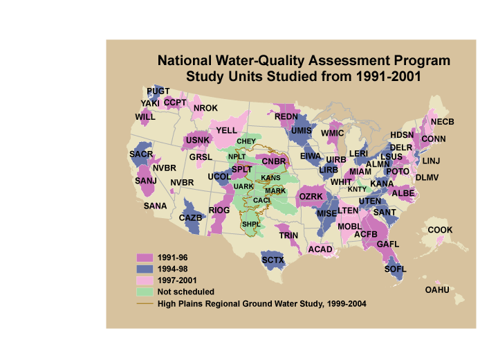
These data were released prior to the October 1, 2016 effective date for the USGS’s policy dictating the review, approval, and release of scientific data as referenced in USGS Survey Manual Chapter 502.8 Fundamental Science Practices: Review and Approval of Scientific Data for Release. This is a GENERALIZED version of the boundaries and codes used for the U.S. Geological Survey's National Water-Quality Assessment (NAWQA) Program Study-Unit investigations in the conterminous United States, excluding the High Plains Regional Ground-Water Study. The data set represents the areas studied during the first decade of the NAWQA Program, from 1991-2001 ("cycle 1"). The coverage is intended only for drawing ILLUSTRATIONS,...
A Groundwater Nitrate Decision Support Tool (GW-NDST) for wells in Wisconsin was developed to assist resource managers with assessing how legacy and possible future nitrate leaching rates, combined with groundwater lag times and potential denitrification, influence nitrate concentrations in wells (Juckem et al. 2024). The GW-NDST relies on several support models, including machine-learning models that require numerous GIS input files. This data release contains all GIS files required to run the GW-NDST and its machine-learning support models. The GIS files are packaged into three ZIP files (WI_County.zip, WT-ML.zip, and WI_Buff1km.zip) which are contained in this data release. Before running the GW-NDST, these ZIP...
Categories: Data;
Types: Map Service,
OGC WFS Layer,
OGC WMS Layer,
OGC WMS Service;
Tags: USGS Science Data Catalog (SDC),
Wisconsin,
aquifer system,
groundwater,
hydrogeology,
A histrogram-based boosted regression tree (HBRT) method was used to predict the depth to the surficial aquifer water table (in feet) throughout the State of Wisconsin. This method used a combination of discrete groundwater levels from the U.S. Geological Survey National Water Information System, continuous groundwater levels from the National Groundwater Monitoring Network, the State of Wisconsin well-construction database, and NHDPlus version 2.1-derived points. The predicted water table depth utilized the HBRT model available through Scikit-learn in Python version 3.10.10. The HBRT model can predict the surficial water table depth for any latitude and longitude for Wisconsin. A total of 48 predictor variables...
Categories: Data;
Types: Map Service,
OGC WFS Layer,
OGC WMS Layer,
OGC WMS Service;
Tags: USGS Science Data Catalog (SDC),
Wisconsin,
aquifer system,
groundwater,
hydrogeology,

These data were released prior to the October 1, 2016 effective date for the USGS’s policy dictating the review, approval, and release of scientific data as referenced in USGS Survey Manual Chapter 502.8 Fundamental Science Practices: Review and Approval of Scientific Data for Release. This geodatabase includes spatial datasets that represent the Cambrian-Ordovician aquifer system in the States of Wisconsin, Michigan, Minnesota, Iowa, and Illinois. Included are: (1) a polygon dataset that represents the aquifer system extent, (2) raster datasets for the altitude of each aquifer subunit, (3) altitude, or if applicable, thickness contours used to generate the surface rasters, (4) georeferenced images of the figures...

These data were released prior to the October 1, 2016 effective date for the USGS’s policy dictating the review, approval, and release of scientific data as referenced in USGS Survey Manual Chapter 502.8 Fundamental Science Practices: Review and Approval of Scientific Data for Release. This geodatabase includes spatial datasets which represent the Lower Cretaceous aquifer system in the States of Iowa, Kansas, Minnesota, Montana, Nebraska, North Dakota, South Dakota, and Wyoming. Included are: (1) a polygon dataset that represents the aquifer system extent, (2) raster datasets for the altitude of each aquifer subarea, (3) altitude and thickness contours (plus thickness fault lines) used to generate the surface rasters,...
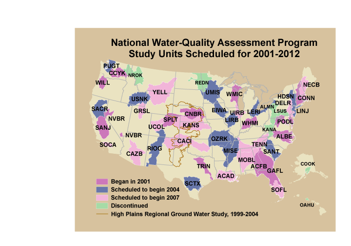
These data were released prior to the October 1, 2016 effective date for the USGS’s policy dictating the review, approval, and release of scientific data as referenced in USGS Survey Manual Chapter 502.8 Fundamental Science Practices: Review and Approval of Scientific Data for Release. This is a GENERALIZED version of the boundaries and codes used for the U.S. Geological Survey's National Water-Quality Assessment (NAWQA) Program Study-Unit investigations in the conterminous United States, excluding the High Plains Regional Ground-Water Study. The data set represents the areas to be studied during the second decade of the NAWQA Program, from 2001-2012 ("cycle 2"). The coverage is intended only for drawing ILLUSTRATIONS,...

These data were released prior to the October 1, 2016 effective date for the USGS’s policy dictating the review, approval, and release of scientific data as referenced in USGS Survey Manual Chapter 502.8 Fundamental Science Practices: Review and Approval of Scientific Data for Release. This geodatabase includes spatial datasets that represent the Mississippian aquifer in the States of Alabama, Illinois, Indiana, Iowa, Kentucky, Maryland, Missouri, Ohio, Pennsylvania, Tennessee, Virginia and West Virginia. The aquifer is divided into three subareas, based on the data availability. In subarea 1 (SA1), which is the aquifer extent in Iowa, data exist of the aquifer top altitude and aquifer thickness. In subarea 2 (SA2),...
These data were released prior to the October 1, 2016 effective date for the USGS’s policy dictating the review, approval, and release of scientific data as referenced in USGS Survey Manual Chapter 502.8 Fundamental Science Practices: Review and Approval of Scientific Data for Release. This is a coverage of the boundaries and codes used for the U.S. Geological Survey's National Water-Quality Assessment (NAWQA) Program Study-Unit investigations in the conterminous United States, excluding the High Plains Regional Ground-Water Study. The data set represents the areas to be studied during the second cycle of the NAWQA Program, from 2001-2012 ("cycle 2").

These data were released prior to the October 1, 2016 effective date for the USGS’s policy dictating the review, approval, and release of scientific data as referenced in USGS Survey Manual Chapter 502.8 Fundamental Science Practices: Review and Approval of Scientific Data for Release. This geodatabase includes spatial datasets that represent the Central Valley aquifer system in the State of California. Included are: (1) polygon extents; datasets that represent the aquifer system extent, the entire extent subdivided into subareas or subunits, (2) raster datasets for the altitude of each aquifer subarea or subunit, (3) altitude, and thickness contours used to generate the surface rasters, (4) georeferenced images...

These data were released prior to the October 1, 2016 effective date for the USGS’s policy dictating the review, approval, and release of scientific data as referenced in USGS Survey Manual Chapter 502.8 Fundamental Science Practices: Review and Approval of Scientific Data for Release. This geodatabase includes spatial datasets that represent the Silurian-Devonian aquifers in the States of Illinois, Indiana, Iowa, Kentucky, Michigan, Missouri, Ohio, Tennessee, and Wisconsin. Included are: (1) polygon extents; datasets that represent the aquifer system extent, and the entire extent subdivided into subareas, (2) raster datasets for the altitude of the top and bottom surfaces of the entire aquifer (where data are...

These data were released prior to the October 1, 2016 effective date for the USGS’s policy dictating the review, approval, and release of scientific data as referenced in USGS Survey Manual Chapter 502.8 Fundamental Science Practices: Review and Approval of Scientific Data for Release. This geodatabase includes spatial datasets that represent the Basin and Range basin-fill aquifers in the States of Arizona, California, Idaho, Nevada, New Mexico, Oregon, and Utah. Included are: (1) polygon extents; datasets that represent the aquifer system extent, the entire extent subdivided into subareas or subunits, and any polygon extents of special interest (outcrop areas, no data available, areas underlying other aquifers,...
The Mississippi Alluvial Plain (MAP) has become one of the most important agricultural regions in the US, and it relies heavily on a groundwater system that is poorly understood and shows signs of substantial change. The heavy use of the available groundwater resources has resulted in significant groundwater-level declines and reductions in base flow in streams within the MAP. These impacts are limiting well production and threatening future water-availability for the region. This product will help not only scientists in our center, but also at a national level. This product will also be part of a larger study encompassing the Mississippi Alluvial Plain region. The Mississippi Alluvial Plain extent was delineated...
Categories: Data;
Types: Downloadable,
Map Service,
OGC WFS Layer,
OGC WMS Layer,
Shapefile;
Tags: Arkansas,
Arkansas River,
Illinois,
Kentucky,
LMG,

These data were released prior to the October 1, 2016 effective date for the USGS’s policy dictating the review, approval, and release of scientific data as referenced in USGS Survey Manual Chapter 502.8 Fundamental Science Practices: Review and Approval of Scientific Data for Release. This geodatabase includes spatial datasets that represent the Southeastern Coastal Plain aquifer system in the States of Alabama, Georgia, Mississippi, South Carolina, and Tennessee. Included are: (1) polygon extents; datasets that represent the aquifer system extent, the entire extent subdivided into subareas or subunits, and any polygon extents of special interest (outcrop areas, no data available, areas underlying other aquifers,...
Categories: pre-SM502.8;
Tags: Alabama,
Black Warrior River Aquifer,
Chattahoochee River Aquifer,
Chickasawhay River aquifer,
Georgia,
These data were released prior to the October 1, 2016 effective date for the USGS’s policy dictating the review, approval, and release of scientific data as referenced in USGS Survey Manual Chapter 502.8 Fundamental Science Practices: Review and Approval of Scientific Data for Release. This is a coverage of the boundaries and codes used for the U.S. Geological Survey's National Water-Quality Assessment (NAWQA) Program Study-Unit investigations in the conterminous United States, excluding the High Plains Regional Ground-Water Study. The data set represents the areas studied during the first decade of the NAWQA Program, from 1991-2001 ("cycle 1").
Categories: pre-SM502.8;
Tags: Aquifer system,
Conterminous United States,
Ground water,
NAWQA,
NSDI,

These data were released prior to the October 1, 2016 effective date for the USGS’s policy dictating the review, approval, and release of scientific data as referenced in USGS Survey Manual Chapter 502.8 Fundamental Science Practices: Review and Approval of Scientific Data for Release. This geodatabase includes spatial datasets that represent the Pennsylvanian aquifers in the Lower Peninsula of Michigan. Included are: (1) polygon extents; datasets that represent the entire aquifer extent in the States of Alabama, Georgia, Illinois, Indiana, Kentucky, Maryland, Michigan, Ohio, Pennsylvania, Tennessee, Virginia, and West Virginia; the entire extent subdivided into subareas or subunits where data exist (Lower Peninsula...
Categories: pre-SM502.8;
Tags: Appalachian Plateau,
Central Lowlands,
Interior Low Plateau,
Lower Peninsula of Michigan,
Lower Pennsylvanian,
|