Filters: Tags: canada (X)
741 results (65ms)|
Filters
Date Range
Extensions (Less)
Types (Less)
Contacts (Less)
Categories (Less)
Tag Types
|
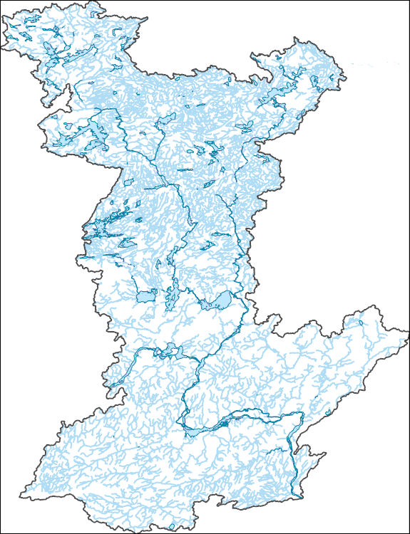
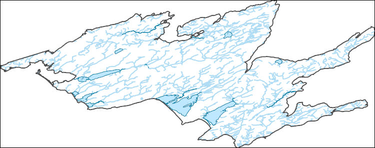
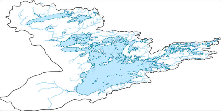
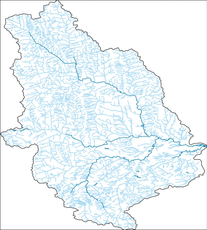
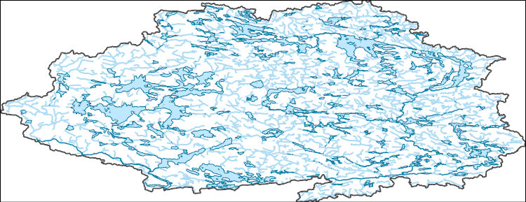
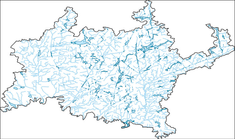
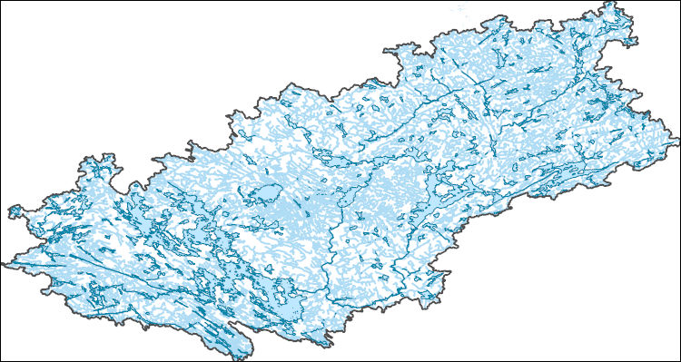
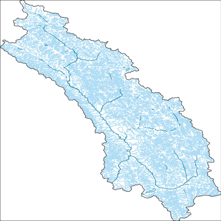
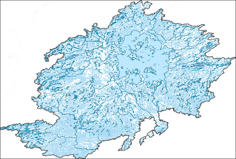
The National Hydrography Dataset (NHD) is a feature-based database that interconnects and uniquely identifies the stream segments or reaches that make up the nation's surface water drainage system. NHD data was originally developed at 1:100,000-scale and exists at that scale for the whole country. This high-resolution NHD, generally developed at 1:24,000/1:12,000 scale, adds detail to the original 1:100,000-scale NHD. (Data for Alaska, Puerto Rico and the Virgin Islands was developed at high-resolution, not 1:100,000 scale.) Local resolution NHD is being developed where partners and data exist. The NHD contains reach codes for networked features, flow direction, names, and centerline representations for areal water...
The National Hydrography Dataset (NHD) is a feature-based database that interconnects and uniquely identifies the stream segments or reaches that make up the nation's surface water drainage system. NHD data was originally developed at 1:100,000-scale and exists at that scale for the whole country. This high-resolution NHD, generally developed at 1:24,000/1:12,000 scale, adds detail to the original 1:100,000-scale NHD. (Data for Alaska, Puerto Rico and the Virgin Islands was developed at high-resolution, not 1:100,000 scale.) Local resolution NHD is being developed where partners and data exist. The NHD contains reach codes for networked features, flow direction, names, and centerline representations for areal water...
The National Hydrography Dataset (NHD) is a feature-based database that interconnects and uniquely identifies the stream segments or reaches that make up the nation's surface water drainage system. NHD data was originally developed at 1:100,000-scale and exists at that scale for the whole country. This high-resolution NHD, generally developed at 1:24,000/1:12,000 scale, adds detail to the original 1:100,000-scale NHD. (Data for Alaska, Puerto Rico and the Virgin Islands was developed at high-resolution, not 1:100,000 scale.) Local resolution NHD is being developed where partners and data exist. The NHD contains reach codes for networked features, flow direction, names, and centerline representations for areal water...
The National Hydrography Dataset (NHD) is a feature-based database that interconnects and uniquely identifies the stream segments or reaches that make up the nation's surface water drainage system. NHD data was originally developed at 1:100,000-scale and exists at that scale for the whole country. This high-resolution NHD, generally developed at 1:24,000/1:12,000 scale, adds detail to the original 1:100,000-scale NHD. (Data for Alaska, Puerto Rico and the Virgin Islands was developed at high-resolution, not 1:100,000 scale.) Local resolution NHD is being developed where partners and data exist. The NHD contains reach codes for networked features, flow direction, names, and centerline representations for areal water...
The National Hydrography Dataset (NHD) is a feature-based database that interconnects and uniquely identifies the stream segments or reaches that make up the nation's surface water drainage system. NHD data was originally developed at 1:100,000-scale and exists at that scale for the whole country. This high-resolution NHD, generally developed at 1:24,000/1:12,000 scale, adds detail to the original 1:100,000-scale NHD. (Data for Alaska, Puerto Rico and the Virgin Islands was developed at high-resolution, not 1:100,000 scale.) Local resolution NHD is being developed where partners and data exist. The NHD contains reach codes for networked features, flow direction, names, and centerline representations for areal water...
The National Hydrography Dataset (NHD) is a feature-based database that interconnects and uniquely identifies the stream segments or reaches that make up the nation's surface water drainage system. NHD data was originally developed at 1:100,000-scale and exists at that scale for the whole country. This high-resolution NHD, generally developed at 1:24,000/1:12,000 scale, adds detail to the original 1:100,000-scale NHD. (Data for Alaska, Puerto Rico and the Virgin Islands was developed at high-resolution, not 1:100,000 scale.) Local resolution NHD is being developed where partners and data exist. The NHD contains reach codes for networked features, flow direction, names, and centerline representations for areal water...
The National Hydrography Dataset (NHD) is a feature-based database that interconnects and uniquely identifies the stream segments or reaches that make up the nation's surface water drainage system. NHD data was originally developed at 1:100,000-scale and exists at that scale for the whole country. This high-resolution NHD, generally developed at 1:24,000/1:12,000 scale, adds detail to the original 1:100,000-scale NHD. (Data for Alaska, Puerto Rico and the Virgin Islands was developed at high-resolution, not 1:100,000 scale.) Local resolution NHD is being developed where partners and data exist. The NHD contains reach codes for networked features, flow direction, names, and centerline representations for areal water...
The National Hydrography Dataset (NHD) is a feature-based database that interconnects and uniquely identifies the stream segments or reaches that make up the nation's surface water drainage system. NHD data was originally developed at 1:100,000-scale and exists at that scale for the whole country. This high-resolution NHD, generally developed at 1:24,000/1:12,000 scale, adds detail to the original 1:100,000-scale NHD. (Data for Alaska, Puerto Rico and the Virgin Islands was developed at high-resolution, not 1:100,000 scale.) Local resolution NHD is being developed where partners and data exist. The NHD contains reach codes for networked features, flow direction, names, and centerline representations for areal water...
The RCMAP (Rangeland Condition Monitoring Assessment and Projection) dataset quantifies the percent cover of rangeland components across western North America using Landsat imagery from 1985-2023. The RCMAP product suite consists of ten fractional components: annual herbaceous, bare ground, herbaceous, litter, non-sagebrush shrub, perennial herbaceous, sagebrush, shrub, tree, and shrub height in addition to the temporal trends of each component. Several enhancements were made to the RCMAP process relative to prior generations. First, high-resolution training was revised using an improved neural-net classifier and modelling approach. These data serve as foundation to the RCMAP approach. The training database was...
The RCMAP (Rangeland Condition Monitoring Assessment and Projection) dataset quantifies the percent cover of rangeland components across western North America using Landsat imagery from 1985-2023. The RCMAP product suite consists of ten fractional components: annual herbaceous, bare ground, herbaceous, litter, non-sagebrush shrub, perennial herbaceous, sagebrush, shrub, tree, and shrub height in addition to the temporal trends of each component. Several enhancements were made to the RCMAP process relative to prior generations. First, high-resolution training was revised using an improved neural-net classifier and modelling approach. These data serve as foundation to the RCMAP approach. The training database was...
The 1966-2022 North American Breeding Bird Survey (BBS) dataset contains avian point count data for more than 700 North American bird taxa (species, races, and unidentified species groupings). These data are collected annually during the breeding season, primarily in June, along thousands of randomly established roadside survey routes in the United States and Canada. Routes are roughly 24.5 miles (39.2 km) long with counting locations placed at approximately half-mile (800-m) intervals, for a total of 50 stops. At each stop, a citizen scientist highly skilled in avian identification conducts a 3-minute point count, recording all birds seen within a quarter-mile (400-m) radius and all birds heard. Surveys begin 30...
The Northeast United States and Atlantic Canada share many of the same types of forests, wetlands, and natural communities, and from a wildlife perspective the region is one contiguous forest. However, resources are classified and mapped differently on the two sides of the border, creating challenges for habitat evaluation, species modeling, and predicting the effects of climate change. To remedy this, ecologists from The Nature Conservancy collaborated with a committee of scientists from various Canadian institutions to produce the first international map of terrestrial habitats for northeast North America. The project used extensive spatial data on geology, soils, landforms, wetlands, elevation and climate. Additionally,...
Categories: Publication;
Types: Citation;
Tags: Canada,
Habitat Map,
Northeast CASC,
Water, Coasts and Ice,
Wetlands
Canada. East side of Vancouver Island, British Columbia. 1899.
The National Hydrography Dataset (NHD) is a feature-based database that interconnects and uniquely identifies the stream segments or reaches that make up the nation's surface water drainage system. NHD data was originally developed at 1:100,000-scale and exists at that scale for the whole country. This high-resolution NHD, generally developed at 1:24,000/1:12,000 scale, adds detail to the original 1:100,000-scale NHD. (Data for Alaska, Puerto Rico and the Virgin Islands was developed at high-resolution, not 1:100,000 scale.) Local resolution NHD is being developed where partners and data exist. The NHD contains reach codes for networked features, flow direction, names, and centerline representations for areal water...
Mr. Brooks. Canada. Yukon Territory. August 25, 1903.
National-scale geologic, geophysical, and mineral resource raster and vector data covering the United States, Canada, and Australia are provided in this data release. The data were compiled as part of the tri-national Critical Minerals Mapping Initiative (CMMI). The CMMI, established in 2019, is an international science collaboration between the U.S. Geological Survey (USGS), Geoscience Australia (GA), and the Geological Survey of Canada (GSC). One aspect of the CMMI is to use national- to global-scale earth science data to map where critical mineral prospectivity may exist using advanced machine learning approaches (Kelley, 2020). The geoscience information presented in this report include the training and evidential...
Categories: Data;
Types: Map Service,
OGC WFS Layer,
OGC WMS Layer,
OGC WMS Service;
Tags: ARDS,
Alaska,
Alaska Mineral Resource Data,
Australia,
Canada,
This U.S. Geological Survey (USGS) metadata release consists of 17 different spatial layers in GeoTIFF format. They are: 1) average water capacity (AWC.zip), 2) percent sand (Sand.zip), 3) percent silt (Silt.zip), 4) percent clay (Clay.zip), 5) soil texture (TEXT_PRMS.zip), 6) land use/land cover (LULC.zip), 7) snow values (Snow.zip), 8) summer rain values (SRain.zip), 9) winter rain values (WRain.zip), 10) leaf presence values (keep.zip), 11) leaf loss values (loss.zip), 12) percent tree canopy (CNPY.zip), 13) percent impervious surface (Imperv.zip), 14) snow depletion curve numbers (Snow.zip), 15) rooting depth (RootDepth.zip), 16) permeability values (Lithology_exp_Konly_Project.zip), and 17) water bodies. All...
Categories: Data;
Tags: Canada,
average water capacity,
boundaries,
conterminous United States of America,
geographic information systems (GIS),
This metadata record documents a set of 118 comma delimited files and a data dictionary describing the inputs for the U.S. Geological Survey Precipitation Runoff Modeling System (PRMS) which is used to drive the National Hydrologic Model (NHM) for the United States-Canada transboundary domain. The National Hydrologic Model database contains parameters for hydrologic response units (HRUs) and stream segments needed to run the NHM. These parameters are generated using python scripts to process input datasets such as digital elevation models, soil maps, and land cover classifications. Many of the parameters were left at their default model value as they would need to be calibrated as part of the PRMS model development...

Multi Order Hydrologic Position (MOHP) raster datasets: Distance from Stream to Divide (DSD) and Lateral Position (LP) have been produced nationally for the 48 contiguous United States at a 30-meter resolution for stream orders 1 through 9. These data are available for testing as predictor variables for various regional and national groundwater-flow and groundwater-quality statistical models. The concept behind MOHP is that for any given point on the earth’s surface there is the potential for longer and longer groundwater flow paths as one goes deeper and deeper beneath the land surface. These increasing depths correspond to increasing stream orders. Or in other words, with increasing depth these paths of groundwater...

These data were released prior to the October 1, 2016 effective date for the USGS’s policy dictating the review, approval, and release of scientific data as referenced in USGS Survey Manual Chapter 502.8 Fundamental Science Practices: Review and Approval of Scientific Data for Release. These data represent the altitude, in feet above North American Vertical Datum of 1988 (NAVD88), of the lower Fort Union aquifer in the Williston structural basin. The data are presented as ASCII text files that can be converted to continuous raster format.
|

|
