Filters: Tags: ground water (X) > Categories: pre-SM502.8 (X)
131 results (12ms)|
Filters
Date Range
Contacts
Tag Types Tag Schemes
|

These data were released prior to the October 1, 2016 effective date for the USGS’s policy dictating the review, approval, and release of scientific data as referenced in USGS Survey Manual Chapter 502.8 Fundamental Science Practices: Review and Approval of Scientific Data for Release. This digital data set defines the lateral boundary of the area simulated by the steady-state ground-water flow model of the Death Valley regional ground-water flow system (DVRFS) by D'Agnese and others (2002). The DVRFS flow model was developed by the U.S. Geological Survey (USGS) for the U.S. Department of Energy (DOE) to support investigations at the Nevada Test Site (NTS) and at Yucca Mountain, Nevada. The model area is an approximately...
Categories: pre-SM502.8;
Tags: Amargosa Desert,
Ash Meadows,
California,
California Valley,
Chicago Valley,

These data were released prior to the October 1, 2016 effective date for the USGS’s policy dictating the review, approval, and release of scientific data as referenced in USGS Survey Manual Chapter 502.8 Fundamental Science Practices: Review and Approval of Scientific Data for Release. This digital data set is a historical definition of the extent (approximately 42,600 square-kilometers) and lateral boundary of the Death Valley regional ground-water flow system (modified from Harrill and others, 1988; and Harrill and Prudic, 1998). Harrill and others (1988) developed boundaries for the major ground-water flow systems in the Great Basin region of Nevada, Utah, and adjacent states using the boundaries of hydrographic...
Categories: pre-SM502.8;
Tags: Amargosa Desert,
Ash Meadows,
California,
California Valley,
Chicago Valley,
These data were released prior to the October 1, 2016 effective date for the USGS’s policy dictating the review, approval, and release of scientific data as referenced in USGS Survey Manual Chapter 502.8 Fundamental Science Practices: Review and Approval of Scientific Data for Release. This raster data set delineates the predicted probability of elevated volatile organic compound (VOC) concentrations in groundwater in the Eagle River watershed valley-fill aquifer, Eagle County, North-Central Colorado, 2006-2007. This data set was developed by a cooperative project between the U.S. Geological Survey, Eagle County, the Eagle River Water and Sanitation District, the Town of Eagle, the Town of Gypsum, and the Upper...
These data were released prior to the October 1, 2016 effective date for the USGS’s policy dictating the review, approval, and release of scientific data as referenced in USGS Survey Manual Chapter 502.8 Fundamental Science Practices: Review and Approval of Scientific Data for Release. This data set shows the ground-water flow lines for the Arikaree aquifer that were used to create a map of the generalized potentiometric surface of the Arikaree aquife rin the Pine Ridge Indian Reseration and Bennett County.
Categories: pre-SM502.8;
Tags: Arikaree aquifer,
Bennett County,
Jackson County,
NSDI,
Pine Ridge Indian Reservation,
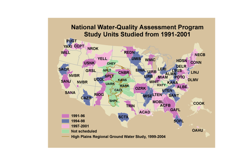
These data were released prior to the October 1, 2016 effective date for the USGS’s policy dictating the review, approval, and release of scientific data as referenced in USGS Survey Manual Chapter 502.8 Fundamental Science Practices: Review and Approval of Scientific Data for Release. This is a coverage of the boundaries and codes used for the U.S. Geological Survey's National Water-Quality Assessment (NAWQA) Program Study-Unit investigations in the conterminous United States, excluding the High Plains Regional Ground-Water Study. The data set represents the areas studied during the first decade of the NAWQA Program, from 1991-2001 ("cycle 1").
Categories: pre-SM502.8;
Tags: Aquifer system,
Conterminous United States,
Ground water,
NAWQA,
NSDI,

These data were released prior to the October 1, 2016 effective date for the USGS’s policy dictating the review, approval, and release of scientific data as referenced in USGS Survey Manual Chapter 502.8 Fundamental Science Practices: Review and Approval of Scientific Data for Release. This data set consists of digital aquifer boundaries for the alluvial and terrace deposits along the Beaver-North Canadian River from the panhandle to Canton Lake in northwestern Oklahoma. Ground water in 830 square miles of the Quaternary-age alluvial and terrace aquifer is an important source of water for irrigation, industrial, municipal, stock, and domestic supplies. The aquifer consists of poorly sorted, fine to coarse, unconsolidated...

These data were released prior to the October 1, 2016 effective date for the USGS’s policy dictating the review, approval, and release of scientific data as referenced in USGS Survey Manual Chapter 502.8 Fundamental Science Practices: Review and Approval of Scientific Data for Release. During 2008, the U.S. Geological Survey and other agencies made approximately 2,500 water-level measurements in the Mojave River and Morongo groundwater basins. These data document recent conditions and, when compared with previous data, changes in groundwater levels. A water-level contour map was drawn using data from about 700 wells, providing coverage for most of the basins. Twenty-four hydrographs show long-term (up to 70 years)...
These data were released prior to the October 1, 2016 effective date for the USGS’s policy dictating the review, approval, and release of scientific data as referenced in USGS Survey Manual Chapter 502.8 Fundamental Science Practices: Review and Approval of Scientific Data for Release. This data set provides information for evaluation of streamflow loss as mechanism of transport of potential contaminants when assessing sensitivity of ground-water to contamination in Lawrence County, SD. This data set is a result of a larger work (WRIR 00-4103 cited above), which includes a paper plate titled: "Map showing sensitivity of ground-water to contamination in Lawrence County, South Dakota." Thirty drainage basins upstream...

These data were released prior to the October 1, 2016 effective date for the USGS’s policy dictating the review, approval, and release of scientific data as referenced in USGS Survey Manual Chapter 502.8 Fundamental Science Practices: Review and Approval of Scientific Data for Release. This data set represents potentiometric surface contours for the Minnelusa aquifer, Black Hills, South Dakota.
Categories: pre-SM502.8;
Tags: Black Hills,
Minnelusa Formation,
Minnelusa aquifer,
NSDI,
South Dakota,

These data were released prior to the October 1, 2016 effective date for the USGS’s policy dictating the review, approval, and release of scientific data as referenced in USGS Survey Manual Chapter 502.8 Fundamental Science Practices: Review and Approval of Scientific Data for Release. The water-budget components geodatabase contains selected data from maps in the, "Selected Approaches to Estimate Water-Budget Components of the High Plains, 1940 through 1949 and 2000 through 2009" report (Stanton and others, 2011). Data were collected and synthesized from existing climate models including the Parameter-Elevation Regressions on Independent Slopes Model (PRISM) (Daly and others, 1994), and the Snow accumulation and...

These data were released prior to the October 1, 2016 effective date for the USGS’s policy dictating the review, approval, and release of scientific data as referenced in USGS Survey Manual Chapter 502.8 Fundamental Science Practices: Review and Approval of Scientific Data for Release. This digital data set defines the flow-system boundary encompassing the regional ground-water flow model by D'Agnese and others (1997). The boundary encompasses an approximately 50,000 square-kilometer region of southern Nevada and California, defined as the Death Valley region by Bedinger and others (1989; see Source Citation Information). The flow-system boundary is mostly a no-flow boundary resulting from physical barriers or...
Categories: pre-SM502.8;
Tags: Amargosa Desert,
Ash Meadows,
California,
California Valley,
Chicago Valley,

These data were released prior to the October 1, 2016 effective date for the USGS’s policy dictating the review, approval, and release of scientific data as referenced in USGS Survey Manual Chapter 502.8 Fundamental Science Practices: Review and Approval of Scientific Data for Release. This digital data set defines the boundary of the steady-state ground-water flow model built by IT Corporation (1996). The regional, 20-layer ground-water flow model was developed for the Underground Test Area (UGTA) Phase I project to simulate the Nevada Test Site and surrounding areas. The model was used for estimating the amount of water moving through the ground-water system, predicting the movement of contaminants, evaluating...
Categories: pre-SM502.8;
Tags: Amargosa Desert,
Ash Meadows,
California,
California Valley,
Chicago Valley,

These data were released prior to the October 1, 2016 effective date for the USGS’s policy dictating the review, approval, and release of scientific data as referenced in USGS Survey Manual Chapter 502.8 Fundamental Science Practices: Review and Approval of Scientific Data for Release. This digital data set represents the constant head-boundary used to simulate ground-water inflow or outflow at the lateral boundary of the Death Valley regional ground-water flow system (DVRFS) transient model. The area simulated by the DVRFS transient ground-water flow model is an approximately 45,000 square-kilometer region of southern Nevada and California. The hydraulic heads imposed at the constant-head cells were interpolated...
Categories: pre-SM502.8;
Tags: Amargosa Desert,
Ash Meadows,
California,
California Valley,
Chicago Valley,

These data were released prior to the October 1, 2016 effective date for the USGS’s policy dictating the review, approval, and release of scientific data as referenced in USGS Survey Manual Chapter 502.8 Fundamental Science Practices: Review and Approval of Scientific Data for Release. A digital three-dimensional (3D) hydrogeologic framework model (HFM) represents the geometry and extent of hydrogeologic units (HGUs) and major structures in the Death Valley regional ground-water flow system (DVRFS). The HFM altitude data represent the geometry of the HFM by defining the top of the 27 HGUs in an approximately 45,000 square-kilometer region of southern Nevada and California (see "Larger Work Citation", Chapter E)....
Categories: pre-SM502.8;
Tags: Amargosa Desert,
Ash Meadows,
California,
California Valley,
Chicago Valley,

These data were released prior to the October 1, 2016 effective date for the USGS’s policy dictating the review, approval, and release of scientific data as referenced in USGS Survey Manual Chapter 502.8 Fundamental Science Practices: Review and Approval of Scientific Data for Release. This digital dataset represents the surface hydrogeology of an approximately 45,000 square-kilometer area of the Death Valley regional ground-water flow system (DVRFS) in southern Nevada and California. Faunt and others (2004) constructed the map by merging mapped lithostratigraphic units into 27 hydrogeologic units (HGUs). The HGUs represent rocks and deposits of considerable lateral extent and distinct hydrologic properties. The...
Categories: pre-SM502.8;
Tags: Amargosa Desert,
Ash Meadows,
California,
California Valley,
Chicago Valley,
These data were released prior to the October 1, 2016 effective date for the USGS’s policy dictating the review, approval, and release of scientific data as referenced in USGS Survey Manual Chapter 502.8 Fundamental Science Practices: Review and Approval of Scientific Data for Release. This data set is a national map of predicted probability of nitrate contamination of shallow ground waters based on a logistic regression (LR) model. The LR model was used to predict the probability of nitrate contamination exceeding 4 mg/L in predominantly shallow, recently recharged ground waters of the United States. The model contains variables representing (1) nitrogen (N) fertilizer loading, (2) percent cropland-pasture, (3)...

These data were released prior to the October 1, 2016 effective date for the USGS’s policy dictating the review, approval, and release of scientific data as referenced in USGS Survey Manual Chapter 502.8 Fundamental Science Practices: Review and Approval of Scientific Data for Release. The water-budget components geodatabase contains selected data from maps in the, "Selected Approaches to Estimate Water-Budget Components of the High Plains, 1940 through 1949 and 2000 through 2009" report (Stanton and others, 2011).Data were collected and synthesized from existing climate models including the Parameter-Elevation Regressions on Independent Slopes Model (PRISM) (Daly and others, 1994), and the Snow accumulation and...
These data were released prior to the October 1, 2016 effective date for the USGS’s policy dictating the review, approval, and release of scientific data as referenced in USGS Survey Manual Chapter 502.8 Fundamental Science Practices: Review and Approval of Scientific Data for Release. This data set describes wells (excluding observation wells) that are completed in the Arikaree aquifer and that were used to create a map of the generalized potentiometric surface of the Arikaree aquifer in the Pine Ridge Indian Reservation and Bennett County. Water levels in the wells were measured by a variety of people including the well drillers and U.S. Geological Survey personnel. The water-level data for this data set are...
Categories: pre-SM502.8;
Tags: Arikaree aquifer,
Bennett County,
Jackson County,
NSDI,
Pine Ridge Indian Reservation,

These data were released prior to the October 1, 2016 effective date for the USGS’s policy dictating the review, approval, and release of scientific data as referenced in USGS Survey Manual Chapter 502.8 Fundamental Science Practices: Review and Approval of Scientific Data for Release. This digital data set defines the subregions of the transient ground-water flow model of the Death Valley regional ground-water flow system (DVRFS). Subregions are used to more readily describe and evaluate the source, occurrence, and movement of ground water within and between the smaller areas of the DVRFS, which is an approximately 45,000 square- kilometer region of southern Nevada and California. The subregions, first described...
Categories: pre-SM502.8;
Tags: Amargosa Desert,
Ash Meadows,
California,
California Valley,
Chicago Valley,

These data were released prior to the October 1, 2016 effective date for the USGS’s policy dictating the review, approval, and release of scientific data as referenced in USGS Survey Manual Chapter 502.8 Fundamental Science Practices: Review and Approval of Scientific Data for Release. This data set consists of depth to ground water contours for hydrographic-area (HA) 153, Diamond Valley, Nevada. These data represent static ground-water levels measured in the HA during March and April of 2001. These data were created as part of an effort to provide statewide information on water table and depth to ground water for Nevada. Digital water-table contours from 38 published reports representing data from 1947 to 2004...
|

|
