Filters: Tags: Hydrology (X) > Date Range: {"choice":"week"} (X)
21 results (29ms)|
Filters
Date Types (for Date Range)
Contacts
Categories Tag Types Tag Schemes |
This data release includes hydroacoustic data for the 2021 to 2022 water years at four stations. These stations are part of a discrete and continuous monitoring project in embayments on Long Island Sound to support nutrient management activities in Connecticut. The data were collected by the U.S Geological Survey (USGS) in cooperation with the Connecticut Department of Energy and Environmental Protection. The data were collected using acoustic doppler current profilers (ADCPs) sampling 134 parameters every six minutes. Recorded values above the water surface were removed from files using an R script. The ADCPs were deployed at upstream and downstream locations in the Mystic and Norwalk embayments. For the Mystic...
The data herein are geochemical (from X-Ray fluorescence spectrometry), grain size (percent clay, silt, sand), lithological (loss on ignition data), bathymetric, reconstructed IVT, and radioactive isotopes (14-C, 210-Pb, 226-Ra, and 137-Cs). These data were collected from sediments from Leonard Lake, Mendocino County, California, USA starting in 2014. Together, these data provide evidence for a record of extreme precipitation going back three millennia, showing regional pluvial and drought cycles.
Categories: Data;
Types: Map Service,
OGC WFS Layer,
OGC WMS Layer,
OGC WMS Service;
Tags: California,
Climatology,
Geography,
Hydrology,
Limnology,
Note: this data release is currently being revised and is temporarily unavailable The U.S. Geological Survey (USGS) Water Resources Mission Area (WMA) is working to address a need to understand where the Nation is experiencing water shortages or surpluses relative to the demand for water need by delivering routine assessments of water supply and demand and an understanding of the natural and human factors affecting the balance between supply and demand. A key part of these national assessments is identifying long-term trends in water availability, including groundwater and surface water quantity, quality, and use. This data release contains Mann-Kendall monotonic trend analyses for 18 observed annual and monthly...
Categories: Data,
Data Release - Under Revision;
Tags: Hydrology,
United States,
Water Resources,
droughts,
floods,
This dataset provides a shapefile of surface water diversions directly to agricultural fields in the Russian River Coupled Groundwater and Surface-Water Flow Model (GSFLOW) model.

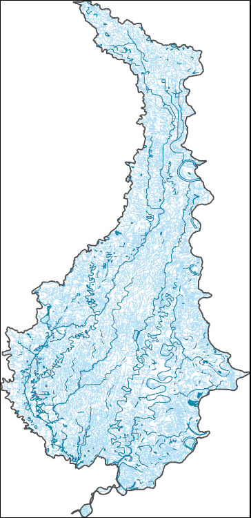
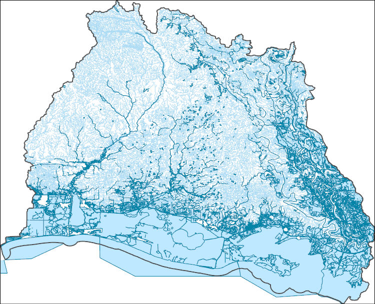
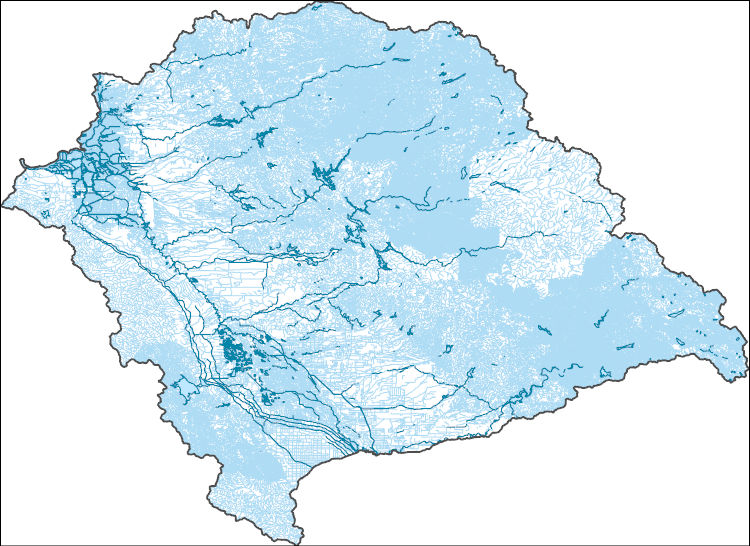
The High Resolution National Hydrography Dataset Plus (NHDPlus HR) is an integrated set of geospatial data layers, including the best available National Hydrography Dataset (NHD), the 10-meter 3D Elevation Program Digital Elevation Model (3DEP DEM), and the National Watershed Boundary Dataset (WBD). The NHDPlus HR combines the NHD, 3DEP DEMs, and WBD to create a stream network with linear referencing, feature naming, "value added attributes" (VAAs), elevation-derived catchments, and other features for hydrologic data analysis. The stream network with linear referencing is a system of data relationships applied to hydrographic systems so that one stream reach "flows" into another and "events" can be tied to and traced...
Since 1993 the U.S. Geological Survey (USGS) has worked with the Alaska Department of Transportation and Public Facilities (ADOT&PF) to provide hydraulic assessments of scour for bridges throughout Alaska. As part of this effort, repeat channel cross section surveys, or channel soundings, have been collected at either the upstream or downstream side of bridges on an annual or as needed basis. Streambed and bank elevations are measured using USGS sounding weights and reels, weighted measuring tapes, acoustic Doppler current profilers, multibeam echo sounders and light detection and ranging and are referenced to the datum of as-built plan set to provide context for the streambed elevations in relation to bridge structures....

The High Resolution National Hydrography Dataset Plus (NHDPlus HR) is an integrated set of geospatial data layers, including the best available National Hydrography Dataset (NHD), the 10-meter 3D Elevation Program Digital Elevation Model (3DEP DEM), and the National Watershed Boundary Dataset (WBD). The NHDPlus HR combines the NHD, 3DEP DEMs, and WBD to create a stream network with linear referencing, feature naming, "value added attributes" (VAAs), elevation-derived catchments, and other features for hydrologic data analysis. The stream network with linear referencing is a system of data relationships applied to hydrographic systems so that one stream reach "flows" into another and "events" can be tied to and traced...
This data release contains U.S. Geological Survey (USGS) field survey data files for selected stream crossing locations in the Squannacook River Basin, north-central Massachusetts. The surveyed stream cross sections and culvert dimensions were used in developing U.S. Army Corps of Engineers (USACE) Hydrologic Engineering Center’s River Analysis System (HEC-RAS) hydraulic models. The data also include original survey notes, survey sketches, and photographs for each field survey conducted at stream crossing locations. The field survey documented and surveyed five stream cross sections for the upstream approach, upstream culvert face, top of road deck, downstream culvert face, and downstream exit. Global Navigation...
Types: Map Service,
OGC WFS Layer,
OGC WMS Layer,
OGC WMS Service;
Tags: Squannacook River Basin,
biota,
floods,
hydraulic modeling,
hydrology,
This data release contains three sets of estimated values at selected sites within the Colorado River Basin: 1) daily specific conductance at 143 sites in the Upper Basin and 3 sites in the Lower Basin (WY 1980-2022); 2) daily baseflow discharge at 100 sites in the Upper Basin and 3 sites in the Lower Basin (WY 1980-2022); and 3) seasonal baseflow discharge and baseflow dissolved solids load at 143 sites in the Upper Basin (WY 1986-2020). The estimates of daily baseflow discharge will be used as input to an application of the USGS GSFLOW model, which is a coupled groundwater and surface-water flow model based on the integration of the USGS Precipitation-Runoff Modeling System (PRMS-V) and the USGS Modular Groundwater...
This data release contains links to two child items containing hydrology and hydraulic modeling data and supplemental geospatial data for selected stream crossing sites in the Squannacook River Basin in north-central Massachusetts. The child item named “Hydraulic model data for selected stream crossing sites in the Squannacook River Basin, North-Central Massachusetts” contains U.S. Army Corps of Engineers’ Hydrologic Engineering Center River Analysis System (HEC-RAS) hydraulic model files along with field survey data associated with each stream crossing location. This data release also includes a data dictionary defining culvert designs, site locations, modeled flows and water surface elevations, and aquatic habitat...
This data release consists of daily mean streamflow, daily mean suspended sediment concentration (SSC), and daily mean suspended sediment load (SSL) data for selected U.S. Geological Survey (USGS) streamgage sites within the Fountain Creek watershed, separated by water year. Each file also includes USGS approval levels and any associated qualifiers that were applied to the values. The daily mean SSC and daily mean SSL were calculated using the program, Graphical Constituent Loading Analysis System (GCLAS) , and are publicly available in the USGS National Water Information System (NWIS) database. Methods used in GCLAS to calculate daily mean SSC and SSL will not be discussed in this data release (see: User's manual...

The High Resolution National Hydrography Dataset Plus (NHDPlus HR) is an integrated set of geospatial data layers, including the best available National Hydrography Dataset (NHD), the 10-meter 3D Elevation Program Digital Elevation Model (3DEP DEM), and the National Watershed Boundary Dataset (WBD). The NHDPlus HR combines the NHD, 3DEP DEMs, and WBD to create a stream network with linear referencing, feature naming, "value added attributes" (VAAs), elevation-derived catchments, and other features for hydrologic data analysis. The stream network with linear referencing is a system of data relationships applied to hydrographic systems so that one stream reach "flows" into another and "events" can be tied to and traced...
The Neversink River watershed (above the Neversink Reservoir) in the Catskill Mountains of New York, USA has been a focus of U.S. Geological Survey research for decades regarding stream geochemistry, acidification, and ecology dynamics. In 2019, the Water Mission Area Next Generation Water Observing Systems Program (NGWOS) augmented the existing stream gage network to include multiscale instrumentation aimed at characterizing various aspects of groundwater discharge to streams, including the collection of paired air and stream water temperature monitoring stations. Groundwater discharge from hillslopes and underlying aquifers acts as an important component of stream baseflow, and influences stream thermal regimes,...
The High Resolution National Hydrography Dataset Plus (NHDPlus HR) is an integrated set of geospatial data layers, including the best available National Hydrography Dataset (NHD), the 10-meter 3D Elevation Program Digital Elevation Model (3DEP DEM), and the National Watershed Boundary Dataset (WBD). The NHDPlus HR combines the NHD, 3DEP DEMs, and WBD to create a stream network with linear referencing, feature naming, "value added attributes" (VAAs), elevation-derived catchments, and other features for hydrologic data analysis. The stream network with linear referencing is a system of data relationships applied to hydrographic systems so that one stream reach "flows" into another and "events" can be tied to and traced...
These data are high-resolution bathymetry (riverbed elevation) and depth-averaged velocities in comma-delimited table format, generated from hydrographic and velocimetric surveys near highway bridge structures over the Missouri and Mississippi Rivers on the periphery of Missouri, June 13–22, 2021. Hydrographic data were collected using a high-resolution multibeam echosounder mapping system (MBMS), which consists of a multibeam echosounder (MBES) and an inertial navigation system (INS) mounted on a marine survey vessel. Data were collected as the vessel traversed the river along planned survey lines distributed throughout the reach. Data collection software integrated and stored the depth data from the MBES and the...
The High Resolution National Hydrography Dataset Plus (NHDPlus HR) is an integrated set of geospatial data layers, including the best available National Hydrography Dataset (NHD), the 10-meter 3D Elevation Program Digital Elevation Model (3DEP DEM), and the National Watershed Boundary Dataset (WBD). The NHDPlus HR combines the NHD, 3DEP DEMs, and WBD to create a stream network with linear referencing, feature naming, "value added attributes" (VAAs), elevation-derived catchments, and other features for hydrologic data analysis. The stream network with linear referencing is a system of data relationships applied to hydrographic systems so that one stream reach "flows" into another and "events" can be tied to and traced...
The High Resolution National Hydrography Dataset Plus (NHDPlus HR) is an integrated set of geospatial data layers, including the best available National Hydrography Dataset (NHD), the 10-meter 3D Elevation Program Digital Elevation Model (3DEP DEM), and the National Watershed Boundary Dataset (WBD). The NHDPlus HR combines the NHD, 3DEP DEMs, and WBD to create a stream network with linear referencing, feature naming, "value added attributes" (VAAs), elevation-derived catchments, and other features for hydrologic data analysis. The stream network with linear referencing is a system of data relationships applied to hydrographic systems so that one stream reach "flows" into another and "events" can be tied to and traced...

The High Resolution National Hydrography Dataset Plus (NHDPlus HR) is an integrated set of geospatial data layers, including the best available National Hydrography Dataset (NHD), the 10-meter 3D Elevation Program Digital Elevation Model (3DEP DEM), and the National Watershed Boundary Dataset (WBD). The NHDPlus HR combines the NHD, 3DEP DEMs, and WBD to create a stream network with linear referencing, feature naming, "value added attributes" (VAAs), elevation-derived catchments, and other features for hydrologic data analysis. The stream network with linear referencing is a system of data relationships applied to hydrographic systems so that one stream reach "flows" into another and "events" can be tied to and traced...
The High Resolution National Hydrography Dataset Plus (NHDPlus HR) is an integrated set of geospatial data layers, including the best available National Hydrography Dataset (NHD), the 10-meter 3D Elevation Program Digital Elevation Model (3DEP DEM), and the National Watershed Boundary Dataset (WBD). The NHDPlus HR combines the NHD, 3DEP DEMs, and WBD to create a stream network with linear referencing, feature naming, "value added attributes" (VAAs), elevation-derived catchments, and other features for hydrologic data analysis. The stream network with linear referencing is a system of data relationships applied to hydrographic systems so that one stream reach "flows" into another and "events" can be tied to and traced...
This data release contains self-potential (SP) map data, two-dimensional electrical resistivity tomography (ERT) data, and time-lapse SP-monitoring data measured within the thermal springs discharge area of Hot Springs National Park in Hot Springs, Arkansas, in addition to the geospatial coordinates of each geophysical measurement and photographs of the reconnaissance and monitoring-survey layouts. Hot Springs National Park features 47 artesian thermal springs that discharge along the trace of a thrust fault at the base of Hot Springs Mountain. To better understand temporal aspects of thermal springs discharge at Hot Springs National Park, the U.S. Geological Survey, in collaboration with the U.S. National Park...
|

|
