Filters: Tags: Water Resources (X) > partyWithName: U.S. Geological Survey (X)
709 results (140ms)|
Filters
Date Range
Extensions
Types
Contacts
Categories
Tag Types
|
The High Resolution National Hydrography Dataset Plus (NHDPlus HR) is an integrated set of geospatial data layers, including the best available National Hydrography Dataset (NHD), the 10-meter 3D Elevation Program Digital Elevation Model (3DEP DEM), and the National Watershed Boundary Dataset (WBD). The NHDPlus HR combines the NHD, 3DEP DEMs, and WBD to create a stream network with linear referencing, feature naming, "value added attributes" (VAAs), elevation-derived catchments, and other features for hydrologic data analysis. The stream network with linear referencing is a system of data relationships applied to hydrographic systems so that one stream reach "flows" into another and "events" can be tied to and traced...
The High Resolution National Hydrography Dataset Plus (NHDPlus HR) is an integrated set of geospatial data layers, including the best available National Hydrography Dataset (NHD), the 10-meter 3D Elevation Program Digital Elevation Model (3DEP DEM), and the National Watershed Boundary Dataset (WBD). The NHDPlus HR combines the NHD, 3DEP DEMs, and WBD to create a stream network with linear referencing, feature naming, "value added attributes" (VAAs), elevation-derived catchments, and other features for hydrologic data analysis. The stream network with linear referencing is a system of data relationships applied to hydrographic systems so that one stream reach "flows" into another and "events" can be tied to and traced...
The High Resolution National Hydrography Dataset Plus (NHDPlus HR) is an integrated set of geospatial data layers, including the best available National Hydrography Dataset (NHD), the 10-meter 3D Elevation Program Digital Elevation Model (3DEP DEM), and the National Watershed Boundary Dataset (WBD). The NHDPlus HR combines the NHD, 3DEP DEMs, and WBD to create a stream network with linear referencing, feature naming, "value added attributes" (VAAs), elevation-derived catchments, and other features for hydrologic data analysis. The stream network with linear referencing is a system of data relationships applied to hydrographic systems so that one stream reach "flows" into another and "events" can be tied to and traced...
The High Resolution National Hydrography Dataset Plus (NHDPlus HR) is an integrated set of geospatial data layers, including the best available National Hydrography Dataset (NHD), the 10-meter 3D Elevation Program Digital Elevation Model (3DEP DEM), and the National Watershed Boundary Dataset (WBD). The NHDPlus HR combines the NHD, 3DEP DEMs, and WBD to create a stream network with linear referencing, feature naming, "value added attributes" (VAAs), elevation-derived catchments, and other features for hydrologic data analysis. The stream network with linear referencing is a system of data relationships applied to hydrographic systems so that one stream reach "flows" into another and "events" can be tied to and traced...

The High Resolution National Hydrography Dataset Plus (NHDPlus HR) is an integrated set of geospatial data layers, including the best available National Hydrography Dataset (NHD), the 10-meter 3D Elevation Program Digital Elevation Model (3DEP DEM), and the National Watershed Boundary Dataset (WBD). The NHDPlus HR combines the NHD, 3DEP DEMs, and WBD to create a stream network with linear referencing, feature naming, "value added attributes" (VAAs), elevation-derived catchments, and other features for hydrologic data analysis. The stream network with linear referencing is a system of data relationships applied to hydrographic systems so that one stream reach "flows" into another and "events" can be tied to and traced...
The final inverted resistivity models within the “Airborne electromagnetic surveys of the Mississippi Alluvial Plain and Chicot Aquifer System, March 2018 and May - August 2021: Resistivity Models” child item are broken up according to the three main objectives of these surveys: River surveys along the thalweg of major rivers with the MAP and the Chicot Aquifer extents; Levee surveys along the Mississippi and Arkansas rivers from Cairo, IL to Baton Rouge, LA and northwest from the confluence of the Mississippi and Arkansas rivers to Pine Bluff, AR; and gridded products mainly focused on gravel bars within the Mississippi River from Helena, MS to the confluence with the Arkansas River. The data in this child item...
Categories: Data;
Tags: Arkansas,
Arkansas River,
Bayou Lacassine,
Bayou Teche,
Big Sunflower River,
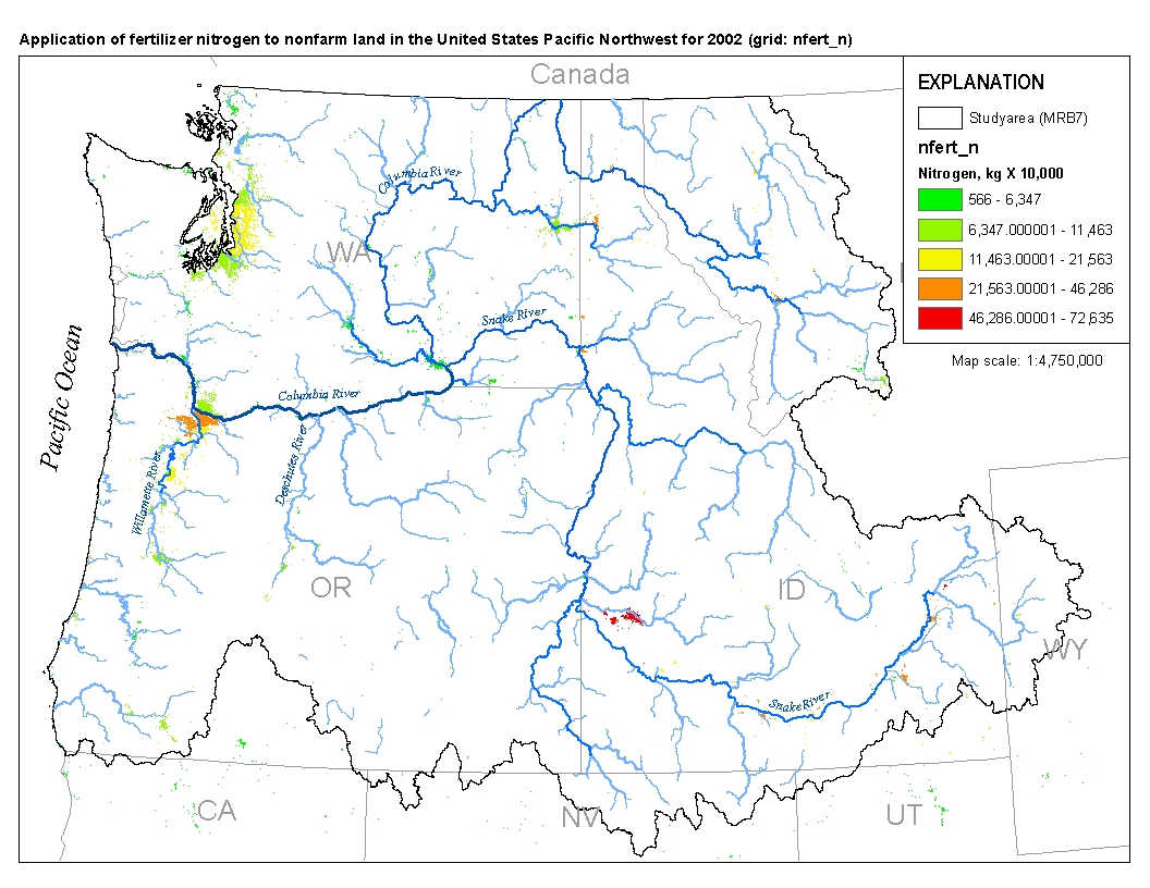
This spatial data set was created by the U.S. Geological Survey (USGS) to represent the amount of fertilizer nitrogen that was applied to nonfarm land in the Pacific Northwest region of the United States (Hydro Region 17; Major River Basin 7 (MRB7)) during 2002.
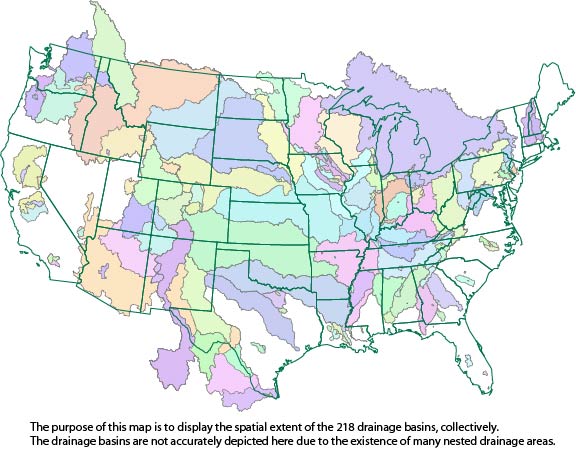
This dataset consists of drainage basin boundaries for 212 U.S. Geological Survey (USGS) stream sites sampled in the National Water-Quality Assessment (NAWQA) Program, the National Stream Quality Accounting Network (NASQAN), and the National Monitoring Network (NMN). Of the 212 sites, 206 have either a contributing or total drainage basin boundary, and the remaining 6 have both a total drainage basin boundary and a smaller contributing basin boundary. Collectively, these 218 basin boundaries have been used in a geographic information system (GIS) to generate basin characteristics for the assessment of trends in concentrations of pesticides streams of the United States.
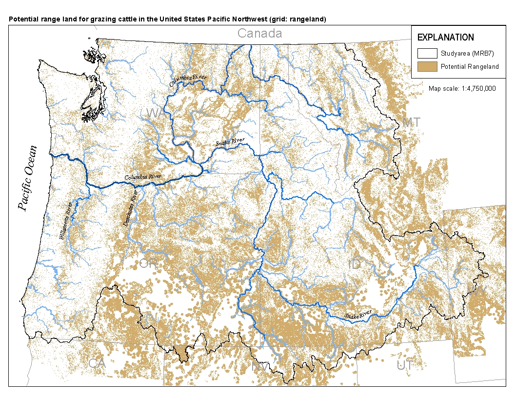
This spatial data set was created by the U.S. Geological Survey (USGS) to represent the extent of land in the Pacific Northwest region of the United States (Hydro Region 17; Major River Basin 7 (MRB7)) that potentially received waste from grazing cattle in 2002.
This data release contains monthly 270-meter resolution Basin Characterization Model (BCMv8) climate and hydrologic variables for Localized Constructed Analog (LOCA; Pierce et al., 2014)-downscaled CNRM-CM5 Global Climate Model (GCM) for Representative Concentration Pathway (RCP) 4.5 (medium-low emissions) and 8.5 (high emissions) for hydrologic California. The LOCA climate scenarios span water years 1950 to 2099 with greenhouse-gas forcings beginning in 2006. The LOCA downscaling method has been shown to produce better estimates of extreme events and reduces the common downscaling problem of too many low-precipitation days (Pierce et al., 2014). Ten GCMs were selected from the full ensemble of models from the fifth...
Clean water is important for a variety of uses, including drinking, recreation, and as habitat for aquatic species. Nonpoint-source pollution, such as nutrients, sediment, and pesticides from agricultural runoff, is a major cause of impaired water quality in the United States . Vegetation and soil in natural land cover help to remove pollutants from runoff water before it reaches streams and other waterways by slowing water flow and physically trapping sediment. To assess the spatial distribution of water purification potential in the southeastern United States, we mapped the demand for purification as the total area of agricultural land and the supply of natural land cover in the flowpath over which water moves...
Categories: Data;
Types: Downloadable,
Map Service,
OGC WFS Layer,
OGC WMS Layer,
Shapefile;
Tags: Alabama,
Arkansas,
Florida,
Georgia,
Louisiana,
NOTE: This data release has been deprecated. In support of the USGS LandCarbon project, field observations of stream and lake carbon gas fluxes and other water-quality data were collected from surface waters in the conterminous US. The sampling was designed to cover a variety of geographic, climatic, and environmental settings to better understand the ranges and distributions of carbon gas fluxes from surface waters. Field observations of carbon gas concentration and flux were paired with laboratory measurements of stream chemical characteristics. Locations were derived from field GPS values or from listed coordinates of USGS streamgages located at the sampling site. Discharge data was either measured in the field...
Categories: Data;
Types: Citation;
Tags: Carbon cycle,
Conterminous U.S.,
Inland waters,
USGS Science Data Catalog (SDC),
Water Resources
Towed transient electromagnetic (tTEM) data were acquired adjacent to the Tallahatchie River during March 2018. During the survey, approximately 35 line-kilometers were collected in the Shellmound, Mississippi study area. Data were collected by members of the U.S. Geological Survey, Hydrogeophysics Branch, and the Aarhus University HydroGeophysics Group. FloaTEM data acquired near the Tallahatchie River in Leflore County, in Mississippi, were collected to characterize the subsurface resistivity structure in support of a U.S. Geological Survey groundwater investigation of the Mississippi Alluvial Plain. tTEM data were collected using an Aarhus University HydroGeophysics Group tTEM unit using a transmitter loop (Tx)...
This dataset provides baseline concentrations (from 2014) of polycyclic aromatic hydrocarbon (PAH), other aromatic organic compounds, mercury (Hg), and trace metal concentrations in sediment and biota collected from two sites along an existing rail line used for coal transport in the Columbia River Gorge, Washington. For this study, aquatic surface sediments, aquatic insects, and juvenile fish were collected in 2014 from Horsethief Lake in Columbia Hills State Park and Steigerwald Lake National Wildlife Refuge (NWR), both located in close proximity to the rail line and within the Columbia River Gorge National Scenic Area. Samples were collected from two subsites in each area: one closer to the rail line and one...
Categories: Data;
Tags: Aquatic Biology,
Environmental Health,
USGS Science Data Catalog (SDC),
Water Quality,
contamination and pollution,
A soil-water balance model (SWB) was developed to estimate potential recharge and surface runoff for portions of the Cannon River drainage basin, southeast Minnesota, for the period 1995 through 2010. The model was used in the creation of Cannon River streamflow distribution maps, as part of the associated report, U.S. Geological Survey Scientific Investigations Map 2017-3390 (http://dx.doi.org/10.3133/SIM20173390). This SWB model was calibrated using three independent hydrograph separation models: PART, Hysep-fixed, and Hysep-sliding method. The basic framework for this model was the statewide Minnesota SWB potential recharge model, described, calibrated, and documented as part of U.S. Geological Survey Scientific...
This product is a series of six national 1-kilometer (km) raster datasets, for five year intervals between 1985 and 2010, representing USGS Water Use "Total Fresh Water Withdrawals", allocated to areas of land use representing anthropogenic use. Pixels representing anthropogenic uses (urban, agriculture, and mining land uses) are derived from the NAWQA Wall-to-wall Anthropogenic Land-use Trends (NWALT) product (Falcone, 2015), a series of decadal national raster datasets for the period 1974-2012. The raster datasets created here are intended as a source of information for estimating water use for watersheds, at the scale of HUC12 watersheds and coarser. Units are millions of gallons per day (mgd) per square km.
Types: Citation;
Tags: Anthropogenic water use,
Conterminous U.S.,
Dasymetric mapping,
Freshwater withdrawals,
Land use,
This data release contains the forcings and outputs of 7-day ahead maximum water temperature forecasting models that makes predictions at 70 river reaches in the upper Delaware River Basin. This section includes model parameters and metadata used to configure reservoir models.
Geomorphology monitoring sites at 15 locations along the Roanoke River in Salem and Roanoke, Virginia, represented riffle or pool habitats and were designed to facilitate repeated measuring at the same cross section over time. Local bench marks were installed at each site to provide both horizontal and vertical control. At a minimum, each site had two bench marks (designated BM) and two transect control marks (designated TC) that were tied together through a static survey-grade Global Positioning System (GPS) survey to establish control to the nearest centimeter. Annual cross-section topographic surveys were conducted during summer low-flow periods at the 15 geomorphology monitoring sites using a total station from...
This dataset includes model inputs (specifically, weather and flags for predicted ice-cover) and is part of a larger data release of lake temperature model inputs and outputs for 7,150 lakes in the U.S. states of Minnesota and Wisconsin (http://dx.doi.org/10.5066/P9CA6XP8).
Land plays a critical role in both economic and environmental accounting. As an asset, it occupies a unique position at the intersection of the System of National Accounts (SNA), the System of Environmental-Economic Accounting Central Framework (SEEA-CF), and (as a spatial unit) SEEA Experimental Ecosystem Accounting (SEEA-EEA), making land a natural starting point for developing natural capital accounts more generally. We develop a pilot set of national and sub-national land accounts for the United States that are consistent with the SEEA-CF and SNA principles, quantified in both physical and monetary terms. The physical accounts utilize detailed land use (National Land Use Database) and land cover (National Land...
|

|
