Filters
Date Range
Types
Contacts
Tag Types
Tags (with Scheme=The National Map Product Extent Thesaurus)
|

Geospatial data that is a derivative land cover product depicting woodland on topographic maps.
Types: Citation;
Tags: Agricultural land,
Barren land,
Downloadable Data,
Forest land,
Land Cover, All tags...
Land Cover - Woodland,
MS,
Mississippi,
Not Classified,
Orthoimage,
Range land,
Shapefile,
State,
US,
US,
United States,
Urban and built-up land,
Water,
Wetland,
Woodland,
annotations,
biota,
ecology,
environment,
farming,
flora,
habitat,
imagery,
imageryBaseMapsEarthCover,
land cover, Fewer tags

Geospatial data is comprised of government boundaries.
Types: Citation;
Tags: Adams,
Allen,
Bartholomew,
Benton,
Blackford, All tags...
Boone,
Boundaries,
Brown,
Carroll,
Cass,
Clark,
Clay,
Clinton,
County or Equivalent,
Crawford,
Daviess,
DeKalb,
Dearborn,
Decatur,
Delaware,
Downloadable Data,
Dubois,
Elkhart,
Esri File GeoDatabase 10,
Fayette,
FileGDB,
Floyd,
Fountain,
Franklin,
Fulton,
Gibson,
Grant,
Greene,
Hamilton,
Hancock,
Harrison,
Hendricks,
Henry,
Howard,
Huntington,
IN,
Incorporated Place,
Indiana,
Jackson,
Jasper,
Jay,
Jefferson,
Jennings,
Johnson,
Jurisdictional,
Knox,
Kosciusko,
LaGrange,
LaPorte,
Lake,
Lawrence,
Madison,
Marion,
Marshall,
Martin,
Miami,
Minor Civil Division,
Monroe,
Montgomery,
Morgan,
National Boundary Dataset (NBD),
National Boundary Dataset (NBD),
Native American Area,
Newton,
Noble,
Ohio,
Orange,
Owen,
PLSS First Division,
PLSS Special Survey,
PLSS Township,
Parke,
Perry,
Pike,
Porter,
Posey,
Public Land Survey System,
Pulaski,
Putnam,
Randolph,
Reserve,
Ripley,
Rush,
Scott,
Shelby,
Spencer,
St. Joseph,
Starke,
State,
State,
State or Territory,
Steuben,
Sullivan,
Switzerland,
Tippecanoe,
Tipton,
U.S. National Grid,
US,
Unincorporated Place,
Union,
United States,
Vanderburgh,
Vermillion,
Vigo,
Wabash,
Warren,
Warrick,
Washington,
Wayne,
Wells,
White,
Whitley,
boundaries,
boundary,
cadastral surveys,
geographic names,
land ownership,
land use maps,
legal land descriptions,
political and administrative boundaries,
zoning maps, Fewer tags

Geospatial data is comprised of government boundaries.
Types: Citation;
Tags: Adams,
Allen,
Ashland,
Ashtabula,
Athens, All tags...
Auglaize,
Belmont,
Boundaries,
Brown,
Butler,
Carroll,
Champaign,
Clark,
Clermont,
Clinton,
Columbiana,
Coshocton,
County or Equivalent,
Crawford,
Cuyahoga,
Darke,
Defiance,
Delaware,
Downloadable Data,
Erie,
Esri File GeoDatabase 10,
Fairfield,
Fayette,
FileGDB,
Franklin,
Fulton,
Gallia,
Geauga,
Greene,
Guernsey,
Hamilton,
Hancock,
Hardin,
Harrison,
Henry,
Highland,
Hocking,
Holmes,
Huron,
Incorporated Place,
Jackson,
Jefferson,
Jurisdictional,
Knox,
Lake,
Lawrence,
Licking,
Logan,
Lorain,
Lucas,
Madison,
Mahoning,
Marion,
Medina,
Meigs,
Mercer,
Miami,
Minor Civil Division,
Monroe,
Montgomery,
Morgan,
Morrow,
Muskingum,
National Boundary Dataset (NBD),
National Boundary Dataset (NBD),
Native American Area,
Noble,
OH,
Ohio,
Ottawa,
PLSS First Division,
PLSS Special Survey,
PLSS Township,
Paulding,
Perry,
Pickaway,
Pike,
Portage,
Preble,
Public Land Survey System,
Putnam,
Reserve,
Richland,
Ross,
Sandusky,
Scioto,
Seneca,
Shelby,
Stark,
State,
State,
State or Territory,
Summit,
Trumbull,
Tuscarawas,
U.S. National Grid,
US,
Unincorporated Place,
Union,
United States,
Van Wert,
Vinton,
Warren,
Washington,
Wayne,
Williams,
Wood,
Wyandot,
boundaries,
boundary,
cadastral surveys,
geographic names,
land ownership,
land use maps,
legal land descriptions,
political and administrative boundaries,
zoning maps, Fewer tags

Geospatial data is comprised of government boundaries.
Types: Citation;
Tags: Alcona,
Alger,
Allegan,
Alpena,
Antrim, All tags...
Arenac,
Baraga,
Barry,
Bay,
Benzie,
Berrien,
Boundaries,
Branch,
Calhoun,
Cass,
Charlevoix,
Cheboygan,
Chippewa,
Clare,
Clinton,
County or Equivalent,
Crawford,
Delta,
Dickinson,
Downloadable Data,
Eaton,
Emmet,
Esri File GeoDatabase 10,
FileGDB,
Genesee,
Gladwin,
Gogebic,
Grand Traverse,
Gratiot,
Hillsdale,
Houghton,
Huron,
Incorporated Place,
Ingham,
Ionia,
Iosco,
Iron,
Isabella,
Jackson,
Jurisdictional,
Kalamazoo,
Kalkaska,
Kent,
Keweenaw,
Lake,
Lapeer,
Leelanau,
Lenawee,
Livingston,
Luce,
MI,
Mackinac,
Macomb,
Manistee,
Marquette,
Mason,
Mecosta,
Menominee,
Michigan,
Midland,
Minor Civil Division,
Missaukee,
Monroe,
Montcalm,
Montmorency,
Muskegon,
National Boundary Dataset (NBD),
National Boundary Dataset (NBD),
Native American Area,
Newaygo,
Oakland,
Oceana,
Ogemaw,
Ontonagon,
Osceola,
Oscoda,
Otsego,
Ottawa,
PLSS First Division,
PLSS Special Survey,
PLSS Township,
Presque Isle,
Public Land Survey System,
Reserve,
Roscommon,
Saginaw,
Sanilac,
Schoolcraft,
Shiawassee,
St. Clair,
St. Joseph,
State,
State,
State or Territory,
Tuscola,
U.S. National Grid,
US,
Unincorporated Place,
United States,
Van Buren,
Washtenaw,
Wayne,
Wexford,
boundaries,
boundary,
cadastral surveys,
geographic names,
land ownership,
land use maps,
legal land descriptions,
political and administrative boundaries,
zoning maps, Fewer tags

Geospatial data is comprised of government boundaries.
Types: Citation;
Tags: Adair,
Alfalfa,
Atoka,
Beaver,
Beckham, All tags...
Blaine,
Boundaries,
Bryan,
Caddo,
Canadian,
Carter,
Cherokee,
Choctaw,
Cimarron,
Cleveland,
Coal,
Comanche,
Cotton,
County or Equivalent,
Craig,
Creek,
Custer,
Delaware,
Dewey,
Downloadable Data,
Ellis,
Esri File GeoDatabase 10,
FileGDB,
Garfield,
Garvin,
Grady,
Grant,
Greer,
Harmon,
Harper,
Haskell,
Hughes,
Incorporated Place,
Jackson,
Jefferson,
Johnston,
Jurisdictional,
Kay,
Kingfisher,
Kiowa,
Latimer,
Le Flore,
Lincoln,
Logan,
Love,
Major,
Marshall,
Mayes,
McClain,
McCurtain,
McIntosh,
Minor Civil Division,
Murray,
Muskogee,
National Boundary Dataset (NBD),
National Boundary Dataset (NBD),
Native American Area,
Noble,
Nowata,
OK,
Okfuskee,
Oklahoma,
Oklahoma,
Okmulgee,
Osage,
Ottawa,
PLSS First Division,
PLSS Special Survey,
PLSS Township,
Pawnee,
Payne,
Pittsburg,
Pontotoc,
Pottawatomie,
Public Land Survey System,
Pushmataha,
Reserve,
Roger Mills,
Rogers,
Seminole,
Sequoyah,
State,
State,
State or Territory,
Stephens,
Texas,
Tillman,
Tulsa,
U.S. National Grid,
US,
Unincorporated Place,
United States,
Wagoner,
Washington,
Washita,
Woods,
Woodward,
boundaries,
boundary,
cadastral surveys,
geographic names,
land ownership,
land use maps,
legal land descriptions,
political and administrative boundaries,
zoning maps, Fewer tags

Geospatial data is comprised of government boundaries.
Types: Citation;
Tags: Albany,
Allegany,
Boundaries,
Bronx,
Broome, All tags...
Cattaraugus,
Cayuga,
Chautauqua,
Chemung,
Chenango,
Clinton,
Columbia,
Cortland,
County or Equivalent,
Delaware,
Downloadable Data,
Dutchess,
Erie,
Esri File GeoDatabase 10,
Essex,
FileGDB,
Franklin,
Fulton,
Genesee,
Greene,
Hamilton,
Herkimer,
Incorporated Place,
Jefferson,
Jurisdictional,
Kings,
Lewis,
Livingston,
Madison,
Minor Civil Division,
Monroe,
Montgomery,
NY,
Nassau,
National Boundary Dataset (NBD),
National Boundary Dataset (NBD),
Native American Area,
New York,
New York,
Niagara,
Oneida,
Onondaga,
Ontario,
Orange,
Orleans,
Oswego,
Otsego,
PLSS First Division,
PLSS Special Survey,
PLSS Township,
Public Land Survey System,
Putnam,
Queens,
Rensselaer,
Reserve,
Richmond,
Rockland,
Saratoga,
Schenectady,
Schoharie,
Schuyler,
Seneca,
St. Lawrence,
State,
State,
State or Territory,
Steuben,
Suffolk,
Sullivan,
Tioga,
Tompkins,
U.S. National Grid,
US,
Ulster,
Unincorporated Place,
United States,
Warren,
Washington,
Wayne,
Westchester,
Wyoming,
Yates,
boundaries,
boundary,
cadastral surveys,
geographic names,
land ownership,
land use maps,
legal land descriptions,
political and administrative boundaries,
zoning maps, Fewer tags

Geospatial data is comprised of government boundaries.
Types: Citation;
Tags: AS,
American Samoa,
Boundaries,
County or Equivalent,
Downloadable Data, All tags...
Eastern,
Esri File GeoDatabase 10,
FileGDB,
Incorporated Place,
Jurisdictional,
Manu'a,
Minor Civil Division,
National Boundary Dataset (NBD),
National Boundary Dataset (NBD),
Native American Area,
PLSS First Division,
PLSS Special Survey,
PLSS Township,
Public Land Survey System,
Reserve,
Rose Island,
State,
State,
State or Territory,
Swains Island,
U.S. National Grid,
US,
Unincorporated Place,
United States,
Western,
boundaries,
boundary,
cadastral surveys,
geographic names,
land ownership,
land use maps,
legal land descriptions,
political and administrative boundaries,
zoning maps, Fewer tags

Geospatial data is comprised of government boundaries.
Types: Citation;
Tags: AZ,
Apache,
Arizona,
Boundaries,
Cochise, All tags...
Coconino,
County or Equivalent,
Downloadable Data,
Esri File GeoDatabase 10,
FileGDB,
Gila,
Graham,
Greenlee,
Incorporated Place,
Jurisdictional,
La Paz,
Maricopa,
Minor Civil Division,
Mohave,
National Boundary Dataset (NBD),
National Boundary Dataset (NBD),
Native American Area,
Navajo,
PLSS First Division,
PLSS Special Survey,
PLSS Township,
Pima,
Pinal,
Public Land Survey System,
Reserve,
Santa Cruz,
State,
State,
State or Territory,
U.S. National Grid,
US,
Unincorporated Place,
United States,
Yavapai,
Yuma,
boundaries,
boundary,
cadastral surveys,
geographic names,
land ownership,
land use maps,
legal land descriptions,
political and administrative boundaries,
zoning maps, Fewer tags

The Geographic Names Information System (GNIS) is the Federal standard for geographic nomenclature. The U.S. Geological Survey developed the GNIS for the U.S. Board on Geographic Names, a Federal inter-agency body chartered by public law to maintain uniform feature name usage throughout the Government and to promulgate standard names to the public. The GNIS is the official repository of domestic geographic names data; the official vehicle for geographic names use by all departments of the Federal Government; and the source for applying geographic names to Federal electronic and printed products of all types. See http://geonames.usgs.gov for additional information.
Types: Citation;
Tags: Antarctica,
Borough,
Census Area,
Commonwealth,
County, All tags...
District,
Downloadable Data,
Feature class,
Feature coordinates,
Feature county,
Feature description,
Feature designation,
Feature history,
Feature identification,
Feature name,
Feature state,
Geographic Names,
Geographic feature,
Geographic name,
Geographical feature,
Geographical name,
Legacy GNIS,
Municipio,
National Geographic Names Information System (GNIS),
Official feature name,
Outlying Area,
Parish,
Place name,
Populated Place,
State,
State,
TXT (pipes),
Territory,
Topographic Map,
United States,
Variant name,
economy,
environment,
imageryBaseMapsEarthCover,
inlandWaters,
location,
society,
structure,
transportation,
utilitiesCommunication, Fewer tags

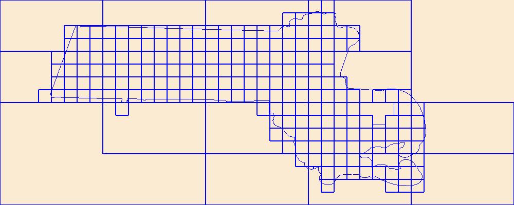
This data represents the map extent for current and historical USGS topographic maps for the United States and Territories, including 1 X 2 Degree, 1 X 1 Degree, 30 X 60 Minute, 15 X 15 Minute, 7.5 X 7.5 Minute, and 3.75 X 3.75 Minute. The grid was generated using ESRI ArcInfo GIS software.
Types: Citation;
Tags: Adams,
Ashland,
Barron,
Bayfield,
Boundaries, All tags...
Brown,
Buffalo,
Burnett,
Calumet,
Chippewa,
Clark,
Columbia,
Crawford,
Dane,
Dodge,
Door,
Douglas,
Downloadable Data,
Dunn,
Eau Claire,
Esri Shapefile nan,
Florence,
Fond du Lac,
Forest,
Grant,
Green,
Green Lake,
Iowa,
Iron,
Jackson,
Jefferson,
Juneau,
Kenosha,
Kewaunee,
La Crosse,
Lafayette,
Langlade,
Lincoln,
Manitowoc,
Map Indices,
Map Indices,
Map Indices,
Marathon,
Marinette,
Marquette,
Menominee,
Milwaukee,
Monroe,
Oconto,
Oneida,
Outagamie,
Ozaukee,
Pepin,
Pierce,
Polk,
Portage,
Price,
Racine,
Richland,
Rock,
Rusk,
Sauk,
Sawyer,
Shapefile,
Shawano,
Sheboygan,
St. Croix,
State,
State,
Taylor,
Trempealeau,
US,
United States,
United States of America,
Vernon,
Vilas,
WI,
Walworth,
Washburn,
Washington,
Waukesha,
Waupaca,
Waushara,
Winnebago,
Wisconsin,
Wood,
cells,
map indices,
polygon grid, Fewer tags
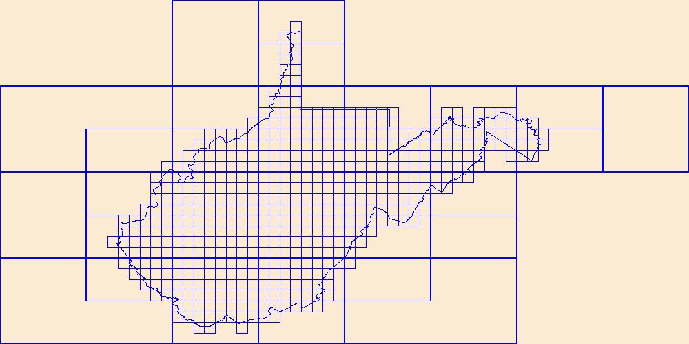
This data represents the map extent for current and historical USGS topographic maps for the United States and Territories, including 1 X 2 Degree, 1 X 1 Degree, 30 X 60 Minute, 15 X 15 Minute, 7.5 X 7.5 Minute, and 3.75 X 3.75 Minute. The grid was generated using ESRI ArcInfo GIS software.
Types: Citation;
Tags: Barbour,
Berkeley,
Boone,
Boundaries,
Braxton, All tags...
Brooke,
Cabell,
Calhoun,
Clay,
Doddridge,
Downloadable Data,
Esri Shapefile nan,
Fayette,
Gilmer,
Grant,
Greenbrier,
Hampshire,
Hancock,
Hardy,
Harrison,
Jackson,
Jefferson,
Kanawha,
Lewis,
Lincoln,
Logan,
Map Indices,
Map Indices,
Map Indices,
Marion,
Marshall,
Mason,
McDowell,
Mercer,
Mineral,
Mingo,
Monongalia,
Monroe,
Morgan,
Nicholas,
Ohio,
Pendleton,
Pleasants,
Pocahontas,
Preston,
Putnam,
Raleigh,
Randolph,
Ritchie,
Roane,
Shapefile,
State,
State,
Summers,
Taylor,
Tucker,
Tyler,
US,
United States,
United States of America,
Upshur,
WV,
Wayne,
Webster,
West Virginia,
Wetzel,
Wirt,
Wood,
Wyoming,
cells,
map indices,
polygon grid, Fewer tags
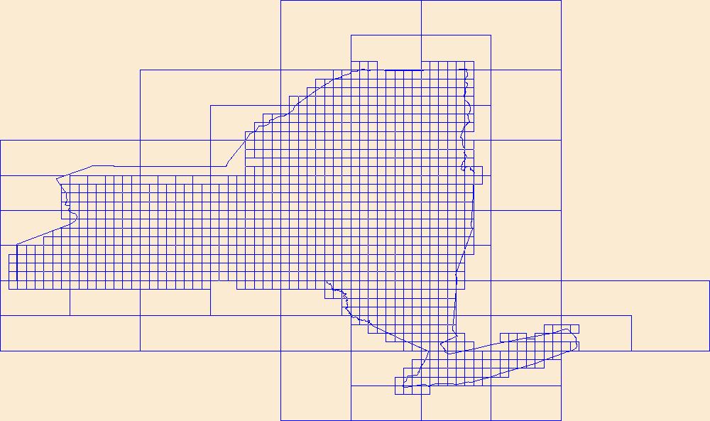
This data represents the map extent for current and historical USGS topographic maps for the United States and Territories, including 1 X 2 Degree, 1 X 1 Degree, 30 X 60 Minute, 15 X 15 Minute, 7.5 X 7.5 Minute, and 3.75 X 3.75 Minute. The grid was generated using ESRI ArcInfo GIS software.
Types: Citation;
Tags: Albany,
Allegany,
Boundaries,
Bronx,
Broome, All tags...
Cattaraugus,
Cayuga,
Chautauqua,
Chemung,
Chenango,
Clinton,
Columbia,
Cortland,
Delaware,
Downloadable Data,
Dutchess,
Erie,
Esri Shapefile nan,
Essex,
Franklin,
Fulton,
Genesee,
Greene,
Hamilton,
Herkimer,
Jefferson,
Kings,
Lewis,
Livingston,
Madison,
Map Indices,
Map Indices,
Map Indices,
Monroe,
Montgomery,
NY,
Nassau,
New York,
New York,
Niagara,
Oneida,
Onondaga,
Ontario,
Orange,
Orleans,
Oswego,
Otsego,
Putnam,
Queens,
Rensselaer,
Richmond,
Rockland,
Saratoga,
Schenectady,
Schoharie,
Schuyler,
Seneca,
Shapefile,
St. Lawrence,
State,
State,
Steuben,
Suffolk,
Sullivan,
Tioga,
Tompkins,
US,
Ulster,
United States,
United States of America,
Warren,
Washington,
Wayne,
Westchester,
Wyoming,
Yates,
cells,
map indices,
polygon grid, Fewer tags
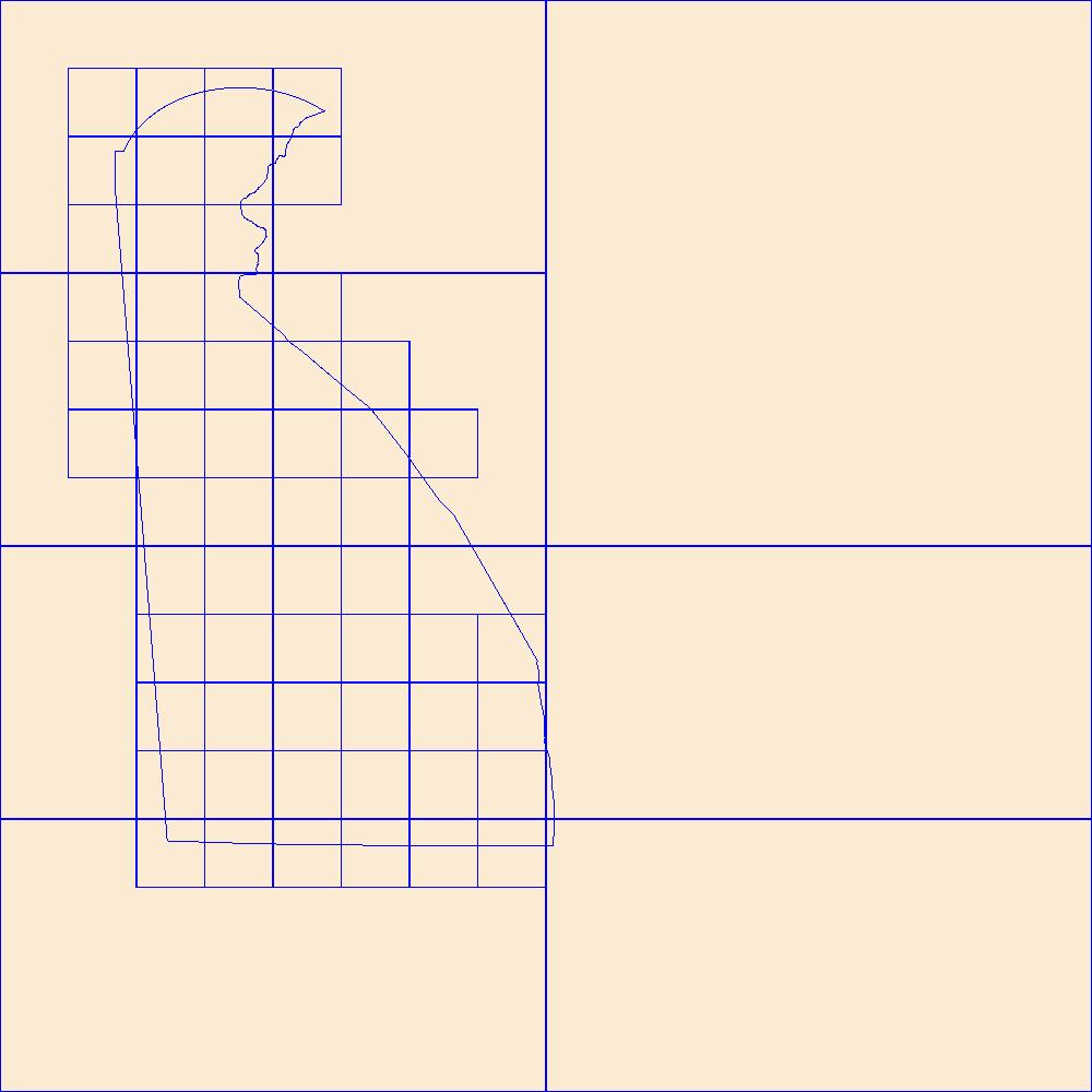
This data represents the map extent for current and historical USGS topographic maps for the United States and Territories, including 1 X 2 Degree, 1 X 1 Degree, 30 X 60 Minute, 15 X 15 Minute, 7.5 X 7.5 Minute, and 3.75 X 3.75 Minute. The grid was generated using ESRI ArcInfo GIS software.
Types: Citation;
Tags: Boundaries,
DE,
Delaware,
Downloadable Data,
Esri Shapefile nan, All tags...
Kent,
Map Indices,
Map Indices,
Map Indices,
New Castle,
Shapefile,
State,
State,
Sussex,
US,
United States,
United States of America,
cells,
map indices,
polygon grid, Fewer tags
This data represents the map extent for current and historical USGS topographic maps for the United States and Territories, including 1 X 2 Degree, 1 X 1 Degree, 30 X 60 Minute, 15 X 15 Minute, 7.5 X 7.5 Minute, and 3.75 X 3.75 Minute. The grid was generated using ESRI ArcInfo GIS software.
Types: Citation;
Tags: Barnstable,
Berkshire,
Boundaries,
Bristol,
Downloadable Data, All tags...
Dukes,
Esri Shapefile nan,
Essex,
Franklin,
Hampden,
Hampshire,
MA,
Map Indices,
Map Indices,
Map Indices,
Massachusetts,
Middlesex,
Nantucket,
Norfolk,
Plymouth,
Shapefile,
State,
State,
Suffolk,
US,
United States,
United States of America,
Worcester,
cells,
map indices,
polygon grid, Fewer tags
|
|

